

Program Overview
MCC’s $448 million Mozambique Compact (2008-2013) sought to improve land policies and regulations, improve the efficiency of land administration services, and expand access to land use through the $39 million Land Tenure Services Project. By reducing costs associated with registering land, increasing land tenure security, and strengthening property rights, the project aimed to improve land use efficiency, increase investment and productivity, and develop land markets, ultimately leading to increased land values and higher incomes.
Evaluator Description
MCC commissioned Social Impact, Inc., Cloudburst and the Duke University Devlab to conduct independent final impact and performance evaluations of the Land Tenure Services Project. Full report results and learning: https://evidence.mcc.gov/evaluations/index.php/catalog/124.
Download Portuguese translated evaluation brief.
Key Findings
Land Administration
- The project strengthened land administration and management in project areas relative to non-project areas, improving efficiency and reducing transaction times.
- However, the process to acquire land certificates is still long, complex, and expensive.
Formality and Land Markets
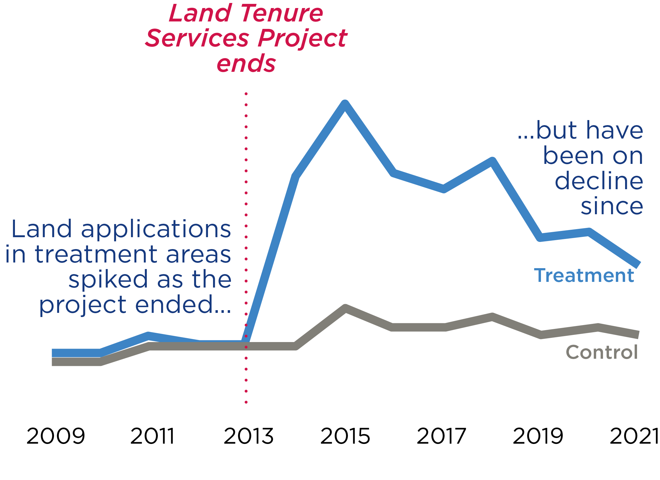
- Despite qualitative evidence of high demand for land certificates, applications have been decreasing towards pre-compact baseline values.
- The project contributed to a modest increase in formal transactions and willingness to rent out land, but legal and institutional barriers continue to constrain land markets.
- Customary systems continue to play a role in land governance and influence how landholders perceive formal land documents.
Land Tenure Security, Investment, and Land Value
- The project strengthened land rights, increased tenure security, and reduced conflict in urban areas, with more limited impacts in rural areas.
- The evaluation did not find evidence that the project resulted in increased investment or associated economic outcomes.
- Reduced perceptions of tenure security in rural project areas compared to non-project areas is likely due to landholders in the project areas not all receiving certificates.
Evaluation Questions
These final impact and performance evaluations were designed to answer numerous evaluation questions including whether the Land Tenure Services Project:
- 1
Had sustained project outputs? - 2
Changed efficiency of land administration? - 3
Improved access to land and land markets? - 4
Changed perceptions of tenure security? - 5
Impacted land investment and utilization?
Detailed Findings
Land Administration

Overall, the Land Tenure Services Project strengthened land administration and management in treatment relative to control areas, but challenges remain. Applicants experienced improved efficiency in processing land rights certificates and reduced transaction times. At the same time, most land offices have significant challenges in land record management, and use of the land information system has largely not been sustained. The evaluation found that for many land offices the land information management system is either not functioning or is being used as a back-up database, requiring a continued reliance on paper records. Overall, the process to acquire a certificate is still long, complex, and expensive.
Formality and Land Markets
Individual land applications
While the demand for land rights certificates is high, applications have been decreasing towards pre-project values since their peak during the compact. Even where rights have been formalized, customary authorities have retained legitimacy and continue to play an important role in land governance. An absence of resources for further systematic regularization post-compact (whereby all parcels in a given area are mapped and given certificates), very few individual applications for certificates in rural areas, and reliance on local structures for conflict resolution are all evidence that the formal system of land administration has not fully taken hold at the community level. There is evidence of more engagement with government land offices and increased individual certificate registration in urban treatment areas, when compared with rural areas.
Land Tenure Security, Investment, and Land Value
The evaluation found that the project affected urban and rural areas differently. In urban treatment areas, there were some improvements in conflict reduction, land rights, and tenure security compared to controls. However, these did not result in the expected impacts on investment, except for large landholders. Instead, there were mostly negative investment effects. This counterintuitive finding might indicate that people in treatment areas feel less of a need to invest in their property as a means for justifying property rights, which has been demonstrated in other contexts.
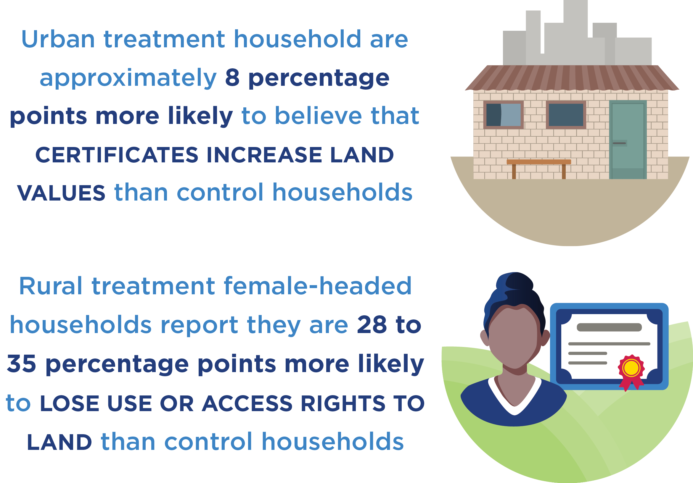
In rural areas, there is weak evidence of reduced conflict and improved perceived tenure security in treatment areas, but no clear evidence of improved tenure security for the overall sample. Specifically for female-headed households in rural areas, the evaluation found a negative impact on perceptions of tenure security - likely the result of incomplete systematic certification, which has left households without certificates feeling less secure.
The evaluation found that the project improved rental markets and increased land valuation across both urban and rural areas, most evidently among urban, large landholders. Like findings from other evaluations, this may indicate that increases in land values were not driven by investment, but rather the ability to rent land with the provision of certificates and/or sell land (albeit informally) in peri-urban contexts that are experiencing rapid urbanization and increasing land values.
MCC Learning
Future land rights recognition projects should do more to anticipate challenges to completing all steps of land formalization that may arise post-Compact.
When land formalization projects do not extend formal rights to all the landholders in the project area, project designs should anticipate and mitigate potential negative spillover effects for landholders in the project area whose land has not been formalized.
Developing and operationalizing land information systems is often challenging and requires flexibility to be built into program design.
Land rights formalization and associated laws, procedures and institutional arrangement reforms must take into account the role of the customary system.
Evaluation Methods
This evaluation applied mixed impact and performance evaluation methods, utilizing difference-in-differences with matching methods to measure impact, alongside cross-sectional and pre-post analysis supplemented with qualitative findings for performance assessment.
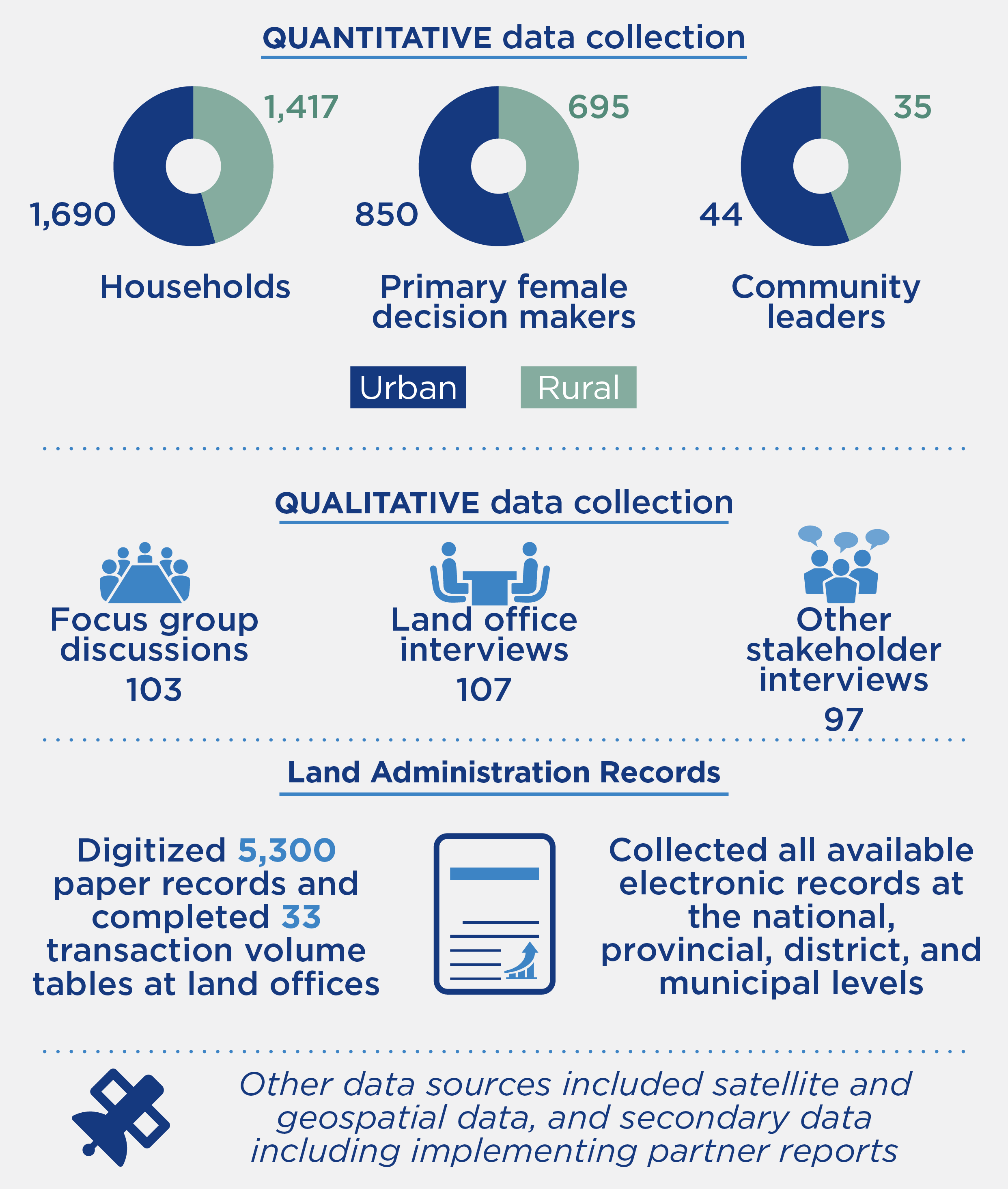
Primary quantitative data collection included panel household surveys (3,107 households), including a module for primary female decision makers (1,545 respondents) and community leader surveys (79 respondents) added at endline. Endline qualitative data collection included 103 focus group discussions with village leaders and beneficiary households, 107 interviews with land administration officials, and 97 interviews with other key stakeholders. This was supplemented by high-resolution satellite imagery, project documents, and land administration data - including digitizing approximately 5,300 paper records.
Endline data collection occurred from 2019 - 2023, with baseline data collection in 2010 - 2014. Project implementation ended in 2013, resulting in an exposure period of between 6 and 10 years.
2024-002-2995